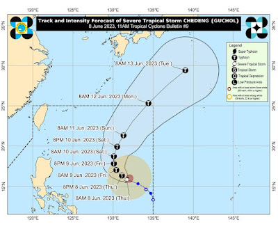
According to PAGASA, “CHEDENG” SLIGHTLY INTENSIFIES AS IT MOVES WEST NORTHWESTWARD OVER THE PHILIPPINE SEA.
TROPICAL CYCLONE BULLETIN NO. 9
Severe Tropical Storm #ChedengPH (GUCHOL)
Issued at 11:00 AM, 08 June 2023
Valid for broadcast until the next bulletin at 5:00 PM today.
Location of Center (10:00 AM):
The center of Severe Tropical Storm CHEDENG was estimated based on all available data at 1,070 km East of Central Luzon (15.9°N, 131.6°E)
Intensity: Maximum sustained winds of 100 km/h near the center, gustiness of up to 125 km/h, and central pressure of 985 hPa
Present Movement: West northwestward at 15 km/h
Extent of Tropical Cyclone Winds:
Strong to gale-force winds extend outwards up to 350 km from the center
TROPICAL CYCLONE WIND SIGNALS (TCWS) IN EFFECT
No Wind Signals hoisted at this time.
HAZARDS AFFECTING LAND AREAS
Heavy Rainfall Outlook
CHEDENG is unlikely to directly bring heavy rainfall over any portion of the country in the next 3 to 5 days.
Although the current forecast scenario for this tropical cyclone may result in the enhancement of the Southwest Monsoon, the timing and intensity of monsoon rains over the country (especially in the western portion) may still change due to the dependence of monsoon enhancement on the forecast movement and intensity of CHEDENG as well as its interaction with the other weather systems surrounding it. As such, the public is advised to continue monitoring for updates regarding the possible enhancement of the Southwest Monsoon. A Weather Advisory will be issued by PAGASA should there be an increasing chance of monsoon heavy rainfall within the next three days.
Severe Winds
The hoisting of Wind Signals in anticipation of tropical cyclone severe winds is unlikely at this time.
The enhancement of the Southwest Monsoon over the next 3 days may bring gusty conditions over the following areas (especially in coastal and upland/mountainous localities exposed to winds):
•Tomorrow: Visayas, Romblon, Occidental Mindoro, the northern portion of Palawan including Kalayaan, Calamian, and Cuyo Islands, Surigao del Norte, Dinagat Islands, and Camiguin.
•Saturday: Visayas, CALABARZON, MIMAROPA, Bicol Region, Camiguin, and Dinagat Islands.
HAZARDS AFFECTING COASTAL WATERS
CHEDENG remains unlikely to cause rough sea condition over the coastal waters of the country in the next 24 hours.
TRACK AND INTENSITY OUTLOOK
•On the forecast track, CHEDENG will remain far from the Philippine landmass. It is forecast to move generally west northwestward to northwestward today through tomorrow before turning more northward tomorrow evening. From this point on, CHEDENG will be slow-moving until Saturday before accelerating on Sunday generally north northeastward or northeastward. This tropical cyclone is expected to exit PAR by Monday morning.
•Owing to favorable environmental conditions, CHEDENG is forecast to intensify in the next 2 to 3 days and may be upgraded into a typhoon by tonight or tomorrow. Peak intensity may be reached by Saturday.
Considering these developments, the public and disaster risk reduction and management offices concerned are advised to take all necessary measures to protect life and property. Persons living in areas identified to be highly or very highly susceptible to these hazards are advised to follow evacuation and other instructions from local officials. For heavy rainfall warnings, thunderstorm/rainfall advisories, and other severe weather information specific to your area, please monitor products issued by your local PAGASA Regional Services Division.
The next tropical cyclone bulletin will be issued at 5:00 PM today.
Link: tinyurl.com/ChedengPH


Comments
Post a Comment