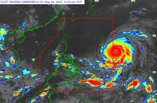
According to the latest report, Super Typhoon "Betty" is projected to rapidly strengthen within the next 24-36 hours. The MARINA-NCR has issued a directive to shipowners, designated persons, boat owners, and concerned entities, urging them to comply with the MARINA Advisory issued on 20 December 2019. This specifically entails the rigorous implementation of the Code of Safety Stowage and Securing in Domestic Shipping.
TROPICAL CYCLONE ADVISORY NO. 6
Super Typhoon “MAWAR”
Issued at 11:00 PM, 26 May 2023
Valid for broadcast until the next advisory at 11:00 AM tomorrow.
SUPER TYPHOON “MAWAR” SLIGHTLY WEAKENS AS IT CONTINUES TO APPROACH THE PHILIPPINE AREA OF RESPONSIBILITY (PAR)
Location of Center (10:00 PM)
The center of the eye of Super Typhoon “MAWAR” was estimated based on all available data at 1,475 km East of Central Luzon (15.8°N, 135.9°E)
Intensity
Maximum sustained winds of 205 km/h near the center, gustiness of up to 250 km/h, and central pressure of 910 hPa
Present Movement
West northwestward at 25 km/h
Extent of Tropical Cyclone Winds
Strong to typhoon-force winds extend outwards up to 570 km from the center
GENERAL OUTLOOK FOR THE FORECAST PERIOD
Track and Intensity:
• Super Typhoon MAWAR is forecast to enter the PAR region tomorrow early morning. On the track forecast, the super typhoon will continue accelerating west northwestward until tomorrow before gradually decelerating on Sunday while maintaining its direction. On Monday, MAWAR will move slowly northwestward over the waters east of Batanes and may become almost stationary, then turn north northeastward on Wednesday.
• MAWAR is forecast to remain as a super typhoon tonight until the weekend, although the chance of slight weakening still remains. However, this tropical cyclone may weaken at faster rate beginning on Monday during its slowdown period due to potential unfavorable conditions (e.g., effect of upwelling of cooler ocean water and dry air intrusion), although it is expected to remain as a typhoon by the end of the forecast period.
• Current forecast scenario shows that the typhoon may bring heavy rainfall over Northern Luzon (especially the northern and western portions) on Monday through Wednesday. In addition, strong to storm-force conditions may be experienced over Extreme Northern Luzon and the northeastern portion of mainland Northern Luzon, while strong to gale-force conditions are possible over the northern and eastern portions of Northern Luzon mainland. As a result, wind signals will be raised by tomorrow in anticipation of these severe winds.
• MAWAR is also forecast to enhance the Southwest Monsoon which may bring monsoon heavy rainfall over the western portions of Southern Luzon and Visayas beginning on Monday and the western portions of Northern and Central Luzon beginning on Wednesday (as MAWAR begins to move away from Luzon).
Considering these developments, the public and disaster risk reduction and management offices concerned are advised to continue monitoring for updates related to this tropical cyclone.
Unless an intermediate advisory or initial tropical cyclone bulletin is released, the next tropical cyclone advisory will be issued at 11:00 AM tomorrow.
DOST-PAGASA


Comments
Post a Comment